Troy Basso Outdoors
"Capturing the outdoor lifestyle"
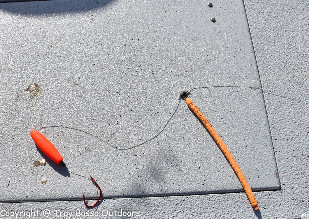
Tip of the week 12/31/18. Dragging tips for big river catfish.
This weeks tip comes from B’n’M catfish pro angler Ryan Lawrence. “When dragging baits use structure snakes instead of traditional lead weights. They are flexible and pull though, and over, structure/cover. Due to their slim profile they tend so come un snagged on the rare occasion they do hang on something. They will save both money and time on the water.”
How To Hunt More & Walk Less… The anatomy of a topographical map
Most Deer and Turkey hunters use maps for one purpose and that is to navigate from place to place. The truth is a map is much more than a navigation or survival tool, it’s an awesome scouting tool as well. In recent years the hand held Global Positioning Systems or GPS have gained in popularity with the outdoor public. The downfall of this electronic wonder is it WILL fail sooner or later. The batteries will die, the canopy won’t let you get a good satellite signal or any of several reason it just won’t work. A map won’t fail, it does not require batteries, clear view of the sky, or a master’s degree to operate. My first GPS unit is at the bottom of the Ohio River for one of those very reasons. If you own a GPS unit and don’t or can’t use topographic maps you are only getting about half of the usefulness out of your unit’s functionality.
The bottom line is if you want to take your hunting to the next level you have to learn to not only read a map but use that same map to make the most of your scouting time. Many miles of unproductive hunting or scouting can be eliminated if, you can apply both what you see on the ground and your knowledge of game, to a topographic map. A perfect example would be a funnel or travel corridor. Most big game hunters can readily identify these two things on the ground but by having the skills to also find them on a map BEFORE you go into a given area can be the difference between a successful hunt and a nice walk.
Now if you can master map reading, and manage to figure out a GPS user’s manual, you’re not only a blooming genius but, you can actually take your hunting knowledge ,your map/GPS skills and combine them to help make you a more effective hunter. I have taken one of my leases and marked all the rubs and scrapes with my GPS for five years, I then download topographic map of the lease. Every year I add to that map. Now I have five years of comprehensive data on one map. Once you do this you will gain a new understanding if how deer travel patterns are directly linked to the terrain in a given area. One other really good reason to always carry a map is the military gave us the GPS technology and even today they still rely on military satellites. Now when the military gets a little excited they tend to mess with the satellites and that can really cause you problems in the field.
A map is, simply stated, a graphic representation of the earth, drawn to scale on a plane surface. Before you can really understand a map you must first understand the information contained both on the map itself and the information in the margins of that map. In the margins you will find the following information.
SHEET NAME – The sheet name is found in the top center part of the map margin, it tells you the maps name. Generally the name is derived from the largest or most prominent feature on the map.
SCALE – The scale can be found in both the upper left and bottom center margins. The scale will tell you the ratio of map distance to the corresponding ground distance. A map with a 1:25000 scale means that one unit of measurement on the map equals 25000 of the same measurement on the ground.
ADJOINING SHEET DIAGRAM – This can be found on the lower left margin and tells you what maps join to the top, bottom, left and right of your current map.
BAR SCALES – The Bar scales can be found in the center of the lower margin and are rulers used to convert map distance to ground distance.
CONTOUR INTERVAL – The contour interval is below the bar scales and tells you the vertical distance between contour lines.
LEGEND – The Legend is usually in the lower left margin. It contains symbols used to depict prominent features on the map you using. Please note that all map legends are not the same, so never assume you know what a symbol is without first checking the legend.
Once you understand the information contained in a map margin you can then get down to the information on the map itself. Next are the colors you will see on a topographic map. There are numerous colors used but here are the basics and what they represent.
BLACK – The color black indicates man made features such as roads, buildings and surveyed elevations.
RED-BROWN – This is the color is used for relief features such as contour lines.
BLUE – The color blue is used to show water like in lakes, streams, rivers or swamps.
GREEN – Green depicts vegetation such as forests, orchards, or vineyards.
After the colors comes the actual terrain features you will find in the body of a map. There are basically eight terrain features that can be broken down into two separate groups. These two groups are major features and minor features. There are five Major terrain features.
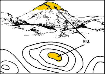
HILL – A hill shows you the top of the hill as viewed from above.
RIDGE – A ridge is nothing more than a series of hills in a row.

Valley – A valley is a gently sloping area generally connected to a stream or river.

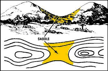
SADDLE – A saddle is the spot between two hilltops.
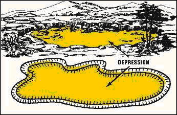
Depression – A depression is what happens when you realize your GPS batteries are dead and your maps are at home. It is also circular spot of land that is lower in elevation than the surrounding terrain and is not filled with water. Good examples would be strip pits and sinkholes.
The next three features are the minor terrain features.
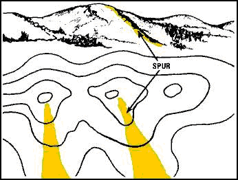
SPUR – A spur looks like a spur on a chicken. Its the part of some hills that sticks out like well, a chickens spur.
DRAW – A draw is a spot that pushes into a hillside.

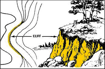
Cliff – A cliff is that thing I always manage to find while navigating in the dark without a map and, a nearly vertical or vertical change in elevation as noted by the extremely close contour lines.
Although this may seem like oversimplification it’s really not. Once you understand the basics of a map the rest will come with experience and familiarity. Map reading and usage is what’s called a perishable skill, which means you can get really rusty if you don’t use the skill regularly. The skills explained here are just the very basics one must have to get started. There is much more to map reading and using a map for scouting. Now you have just enough information to become temporarily disoriented rather than flat out lost.
Tip of the week 12/24/18. Think small for dock shooting.

This weeks tip of the week comes from Frogg Toggs pro Kevin McCarley. “When it comes to dock shooting I like to get small. Small meaning a 1/32 ounce jig head. This keeps my baits in the strike zone longer sure to the slower rate of descent.”